Hospitals & Asylums
A
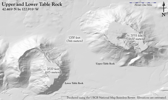
Treaty of Freedom with the Rogue River Tribes: Table Rocks Wilderness Camping
Powwow Petition HA-12-5-11
By A.J. Sanders
To (1) post “$5 a night wilderness camping, Native Americans
and indigents camp free, camping and campfires in designated areas only, no
alcohol, no firearms”,
(2) use the revenues to subsidize RVTD Route 60 to White City
to go the extra 6 miles to Table Rocks for $2 twice a weekday, and
(3) Promote White City S.W.A.T. obstacle course instruction
and competition for the public for a $5 fee.
They appeared entirely
friendly, and have sufficient intelligence to see that neither they nor their people
have anything to gain by hostility with the whites.
Alonzo Skinner,
thirty-seven-year-old lawyer from Ohio, who went to the Rogue River as Indian
agent in 1851
Live, to see the time, when
the Indians of Rogue River are extinct.
A toast at a banquet in 1852
Hi u lum; nika wake memeloose
mika! You are very drunk or I would kill
you!
Tipsu Tyee at a brawl with a
volunteer in 1854
Our hearts are sick of
war. Meet me at Table Rock in seven
days, where we will give up our arms making a treaty.
Chiefs Apserkahar, Toquahear
and Anachaharah to General Joseph Lane after defeating him and treating wounded
U.S. soldiers in August 1853
You are a great chief, so am I. This is my country, I was in it when these
large trees were very small, not taller than my head. My heart is sick with fighting, but I want to
live in my country. If the white people
are willing, I will go back to Deer creek and live among them as I used to do,
they can visit my camp, and I will visit theirs, but I will not lay down my arms
and go with you on the reserve. I will
fight. Good-by.
Chief Tecumtum in
negotiations with Lt. Col. Robert C. Buchannon
Aborigines should be given a
home remote from the settlements where they could be guarded from the influence
of pestiferous white men. They should
have comfortable houses, schools and instruction in farming and Christianity.
Letter from Indian Agent Joel
Palmer dated June 23, 1853
Maybe rural bus routes to bring wilderness campsites within reach
of a grocery store and a shower are the solution to the new
homeless problem in Rogue Valley.
Letter from the author before moving to Rogue Valley dated
September 2, 2010

Credit: U.S. Bureau of the Interior Bureau of Land Management.
Welcome to the Table Rocks. 2011 Hike Registration
I am new
to the area. I lived in White City for a
month during the elections of 2010 when I went to Table Rock and was wrongfully
evicted for religious discrimination shortly after sending a letter of intent
to the Nature Conservancy who manages the public and private lands that
comprise Upper and Lower Table Rock in cooperation with the nearby Medford
office of the Bureau of Land Management.
Without transportation or a digital camera the week has dragged on into
half a year but my sister has finally consented to be weaned of her contagious
couch and give me a ride, but now there are plenty high quality photos on the
web. In recuse for the cold reception I have turned to the Jackson County Board
of Elections to communicate with local Nature Conservancy volunteer Kevin
Talbert who is running unopposed for Rogue Community College Director in Zone 5
(Walker ’11: 15-8). This National
Monument is dedicated to both my neighbors who were evicted for inability to
pay and Aunt Lill (1914-2011) who lived until the age of 97 above the Hollywood
sign, until she died on May 10, 2011.
The purpose of this treaty is to challenge Rogue Valley to open the
Table Rocks for wilderness camping under the Wilderness Act of 1964 (Marsh ’07:
13). 155 years since the natives surrendered on July 8, 1956 and agreed to be
moved from the Table Rock Reservation to reservations on the coast in
abrogation of the Treaty of Peace concluded on September 8, 1853, Treaty for
Sale of Land on September 10, 1853 as well as the land sharing agreement on November 11, 1854 (Schwartz ‘97: 60). It
remains to be seen if Connie Skillman Position 1 Director of the Rogue Valley
Transportation District will extend RVTD
White City Route 60 to Table Rock, Rogue Valley residents will win an
affordable home immune from hospital bills and firearms, from spring to fall
(Walker ’11: 15-21). Jackson County,
Oregon will thereby redress the abrogation of the Table Rock Reservation
Treaties 1853-1856 as a mature, peaceful, tribal and democratic republic of 21st
century denizens of the woods, more fond of powwows than homelessness. The Table Rock mesas are a 9.6 million year old lava flow,
that is only a 2.8 to 5.4 mile walk to the vistas above the Rogue River (Hill
’10: 7).
Lower Table Rock

Credit:
mdvaden Google Earth Panoramio
2.
In the beginning of the twenty-first century, wilderness protection is once
again becoming a dominant issue in the land use debates of both states (Marsh
’07: 142). Hospitals
& Asylums, National Home for Disable Volunteer Soldiers, Battle Mountain
Sanitarium Reserve statute 24USC(3)IV§153 provides that in
all cases of unperfected bona fide
claims to land, said claims may be perfected upon compliance with the
requirements of the laws respecting settlement, residence, improvements, and upon completion of any
exchange the lands surrendered to the Government shall become a part of said reserve
as if they had been public lands at the time of the establishment of said
reserve. The National Wilderness Preservation System recognizes a wilderness as an
area where the earth and its community of life are untrammeled by man, without permanent improvements or human habitation, where man
himself is a visitor who does not remain,
which is protected and managed so as to preserve its natural conditions and (1)
which generally appears to have been affected primarily by
the forces of nature, with the imprint of man’s work substantially
unnoticeable; (2) has outstanding opportunities for solitude
or a primitive and unconfined type of recreation; (3) has at
least five thousand acres of land or is of sufficient size as to make
practicable its preservation and use in an unimpaired condition; and (4) may also contain ecological, geological, or other features
of scientific, educational, scenic, or historical value under 16USC(23)§1131(c). Native American tribes continue to play an
important role in the preservation of our nation’s wilderness. United States v. Alcea Band of Tillamooks 329
US 40 (1946) upheld the un-ratified treaty concluded on August 11,
1855 by Indian Agent Joel Palmer and respondent tribes providing for the
creation of a reservation authorized by President Franklin Pierce on November 9, 1855 a few weeks after the beginning of the Rogue River
War, ultimately awarding
the Molalla tribe, the Umpqua band, and the
Calapooia band of Umpqua Valley nearly $347,000 dollars. The
Confederated Tribes of Siletz, from Rogue Valley had been dropped as plaintiffs
from the Alcea case, but they took their case to the Indian Claims Commission,
which eventually awarded somewhat less than $434,000 under 25USC(14)V§478b. The Table Rocks remains to be restored to the
Confederated Tribes of Siletz who maintain a website at www.ctsi.nsn.us
Dwarf meadowfoam
(Limnanthes floccosa ssp. pumila)

Credit:
Stephen Meyers, Oregon Department of Agriculture
3. Rising dramatically 800 feet
above the Rogue River Valley, the Table Rocks are remnants of lava flows that
filled the canyons of an ancient, meandering Rogue River over 7 million years
ago. Atop these mesas is a mosaic of grassy mounds, stony flats and vernal, or
seasonal, ponds. Located north of
Medford, the Table Rocks figure large in Southwest Oregon history as prominent
landmarks, comprising some 3,591 acres,
that were gathering places for Native Americans, and settlers along the
Oregon-California Trail. The
Nature Conservancy bought land on Lower Table Rock over thirty years ago,
creating our first preserve in the Rogue Valley. In 2008, we acquired an additional
1,710 acres, securing the last remaining private lands on both Upper and Lower
Table Rocks. As a result, the Table Rocks are now owned and collaboratively
managed by the Conservancy and the Bureau of Land Management (BLM), which has
designated its holdings as an Area of Critical Environmental Concern. Remarkable diversity includes a spectacular
wildflower display from March until June with expanses of goldfields, grass
widows and brodiaea. The wildflower dwarf woolly meadowfoam (Limnanthes
floccosa ssp. Pumila) grows
on the top of Upper and Lower Table Rock and nowhere else on Earth. A
federally listed species of fairy shrimp has been discovered inhabiting the
vernal pools. The slopes below the rocks
support Oregon white oak, madrone, ponderosa pine woodlands and Rogue Valley
chaparral. Oak woodlands and chaparral
provide the blue-gray gnatcatcher's northernmost known nesting site. Spring wildflowers begin to bloom in February
and reach their peak during April and May. Watch out for poison oak, rattlesnakes,
ticks and the hazards of steep cliffs. Volunteer teams plant native grasses and
remove weeds, and the Table Rocks provide a popular outdoor classroom for
thousands of school children who visit each year to learn about natural and
cultural history (BLM & Nature Conservancy ’11). While there is no denying that the dwarf
woolly meadowfoam and fairy shrimp are entitled to special protection it cannot
be proven that wilderness camping would threaten their habitat without
experimentally testing the environmental impact caused by (1) a $5 a night
wilderness camping sign and designated campsites with firepits (2) extending
RVTD Route 60 to Table Rock and (3) hosting large powwows organized by the
Confederated Tribes of the Siletz.
Rogue Valley from Upper Table Rock

Credit:
flickr by Yahoo
4. The national heritage of upper
and lower Table Rocks enrich the public with a superlative natural, historic
and recreational opportunity in northern Rogue Valley, Oregon, much like Lava
Bed National Monument in Northern California where the Modoc return from
Oklahoma annually in the summer. Often
ticketed for camping on the watershed, the mostly white Rogue Valley denizens
would be greatly relieved if the RVTD Route 60 bus to White City would take
them, for $2 from the White City grocery store twice a weekday. Before
the war Rogue River peoples numbered around 9,500 in 1851, by the middle of
1857 Indian Service agents counted only 1,943 survivors on the Coast
Reservation of whom around 25% had died of disease by 1858. After a short spell of agricultural
prosperity the General Allotment Act of 1887 and the Dead Indian Act of 1902,
allowed the Indian Service to convert land of deceased Indians into cash, shrinking
the national Indian land base from 138 million acres in 1887 to 52 million acre
in 1934. The Indian Reorganization Act
of 1934 was the centerpiece of the Indian New Deal. The Act removes impediments for judicial
determination of any and all legal and equitable claims arising under original
Indian title, claim, or rights in the lands occupied by the Indian tribes and
bands described in certain un-ratified treaties. From
1953 the Siletz were delisted as a tribe by Congress until restored by Jimmy
Carter in 1975. A consent decree between the Fish and Wildlife Commission and the
tribal council was approved on April 21, 1979 allowing members of the tribes to
take as many as 375 deer and 25 elk annually plus a maximum of 200 salmon. It is time Rogue Valley was returned to the
people. The
Rogue River tribes, now the Confederated
Tribes of Siletz, shall hereby receive all the wilderness camping revenues for
any Ghost Dance they get permission from the Jackson County Sheriff in White
City, they host on the Table Rocks (Schwartz ’97).
Rogue River, White City and Mount
McLoughlin from Lower Table Rock

Credit: kayak_guru
Google Earth Panoramio
5. To
foster physical fitness amongst the brave athletes and improve White City
tourism the Sherriff’s Office S.W.A.T. obstacle course instructor shall hereby
regularly, perhaps on a monthly basis in the spring through fall, offer
instruction and competitions open to the public, for the $5 fee of the firing
range and wilderness camping. White City
is the largest unincorporated community in Oregon, home to approximately 6,000
residents, 29% of Hispanic origin, 69% who do not speak English. During peak
pear harvesting season, over 8,000 additional migrant and seasonal farm workers
swell White City's population. White City is home to the large Veteran’s
Administration (VA) Southern Oregon Rehabilitation Center and Clinic (SORCC).
White City began in 1941, when the U.S. Army constructed Camp White on 43,000
acres outside of Medford, Oregon as an army training camp for the 91st Infantry
Division. Over four years, 40,000 troops shipped out of Camp White. After the
war the military hospital and barracks, were deeded to the VA and reopened as a
free-standing Domiciliary for the Elderly until it was converted to residential
substance abuse treatment center. Until the 1980s, over 30 mills and 6,400 jobs
flourished in the Rogue Valley. With timber industry downturns, unemployment
rose. Social problems multiplied: White City, with only 4% of the population,
had the largest number of domestic violence and child abuse cases, in the
county. The infant mortality rate was double Oregon's statewide average. In
November 1990, local residents formed the White City Community Improvement
Association. WCCIA built and continues to own and operate Cascade Bingo to fund
shoes and clothing for youth, youth activities, Burn's Park, the local Boys and
Girls Club and many local improvement projects; new streets and storm sewers, a
new public library, a new community service center, with a skate park and
indoor swimming pool at Burn’s Park where campers can take showers (CAN
’98-’00). A sign claims “White City: A
Nice Place to Live” and domestic violence seems to have subsided to the normal
$100 robberies of Rogue Valley aristocrats, since the Community Health Center
opened a clinic in White City (Sanders ’10-11).
Pre-contact Tribes in
Southern Oregon and Northern California

Credit: University
of Oregon Department of Linguistic
6. The original inhabitants of southwestern
Oregon were members of multilingual complex of interlocking cultures, focused
on streams and estuaries. It is
estimated that 9,500 people lived in the Rogue River country, usually in
villages with populations of 30 to 150.
The Takelmas, “those dwelling along the river” and their upland
relatives, called the Latgawas, occupied much of the rogue River valley
proper. Salmon was a significant
foodsource. Their houses
were small brush shelters in summer and constructed of split sugar pine boards
for winter. They decorated their costumes with dentalia shells, and tattooing
was common (Johnson ’94: 178). They spoke a
language with Penutian affinities. They
did not get along well with their Shasta neighbors, who they called
enemies. The inland people suffered
smallpox epidemics in the 1770s, 1801, 1824-25 and 1838. Women were in competition with men in the
field of traditional medicine. Among the
Athapascan speakers, doctors were usually women. After long training, they went through a
ten-day initiation during which they got the guardian spirits that helped them
and gave them power. Takelma doctors
were at least as likely to be women as they were to be men. The Takelmas, whose name for doctors was goyo, believed that a doctor had the
power to prevent and cause illness and bad weather. Illness resulted when someone or something
sent pains to penetrate the victim’s body.
These pains were conceptualized as small material objects of different
colors. Through song and dance, a goyo used the power of his or her
guardian spirits to drive out pains. But
pains were thought to respond to more physical methods of healing as well. People often preferred to call on a somlobolxa, a more benign doctor who did
not inflict pains as a goyo might but
was capable of removing them by rubbing the afflicted part of the body. The
natives lived to a great old age, no ancestors had to have any teeth pulled,
for those that were 80 and 90 years old would have very tooth, although some
were worn very close the their gums. One
creation myth was that the creator Qawaneca or Kwawanesha rearranged the earth,
learned from the birds how to make the sun shine, and created the serpent that
is wrapped around the earth five times and holds it together. But Qawaneca failed to become the father of
the Indians because he had a companion, an immortal but lesser being who
tricked the immortal Mother into marrying him, “All Indians return to her at
death, and she sends them back to this world as infants. Her husband, too, is still alive. He never leaves this world; but Qawaneca now
dwells in the sun and looks down on the people.
The circumference of that upper world in which he dwells is curved
upwards. No one who dies here can go to
live Qawaneca. Before the white people came there were no disease of any kind,
no taxes or interest to pay, hence people had all kinds of time for every kind
of pleasure and dances of various kinds carried on for days (Schwartz ’97:
xii,4, 5, 11).
Annual Nesika Illahee Pow Wow

Credit: Confederated Tribes of Siletz Indians of
Oregon August 13-15, 2004
7. White
man’s medicine did not fare any better than white man’s land management in
Rogue Valley. Ashland’s first physician,
David Sisson, became its first murder victim after he was shot on April 5,
1858. His hospital was dismantled after
his death and was the last structure of structure of its kind for fifty years. Ashland remained without a physician until
the early 1870s. When Dr. Brower arrived
in 1893 he found pervasive unsanitary conditions and rampant typhoid fever,
scarlet fever, diphtheria and pneumonitis and directed the clean-up of manure
piles and standing pools of water that eventually controlled the devastating
outbreak. The Ashland Sanitarium had 33
rooms and was advertised for “all curable chronic diseases, surgical appliances
and conveniences now looked upon as indispensable in an operating department of
a hospital”. It will be a public hospital, and no physician has or will have
any interest in it. All physicians are
solicited to bring patients here. On March 11, 1909 the roof of the 300 bed
hospital building burst into flame. Happy
doctors and nurses make for happy patients and a successful hospital. Today the
hospital goes on an annual rafting trip on the Rogue River. At the Halloween party they get recognized
for 5, 10, 15, 20 and 25 years of service (Atwood ’96: 7, 8, 110, 112, 114). Community Health
Center was initially founded in 1972 as the result of an extensive, grassroots,
community-based effort, and exists today as an Oregon non-profit corporation,
which enjoys IRS tax-exempt status. The mission is to promote the health of low-income, working
un-insured, and other vulnerable adults and children in Jackson County,
Oregon. Although the Community Health
Center (CHC) does not seem to have a candidate or revenue measure to defray the
$5 million cost of their operation born by reasonable fees to the poor, like
pricier hospitals, maybe they will heed the Board of Elections and take
responsibility for replacing the word “operation” with “name” on their release
form and require the Ashland Community Hospital remove the carpet and easy
chair from their medical library and offer patrons free latex gloves. Not to mention the $250 bill for 24 hours of
reading and writing (Sanders ’10-11).
Bannock Indians

Credit: Oregon
Historical Society
Quarterly, IV, No.3. 1903, pp. 227-240
8. Direct contact between non-Indians and
inland Rogue River peoples seem to have begun in early 1827. Before 1851
non-Indians had never been more than transients in Rogue River country. In the Spring of 1852, when whites began
coming into the river valley. The Indian
people decided that they could stay as long as they were friendly. The whites
remained friendly for about a year.
Peace broke down while the hunters and nut gatherers were upriver and
the only people left in the village at the mouth of the river were the elderly
and children too young to help with the work.
Before a week or ten days passed the Indians were told that the white
men had burned about forty houses and the people in them (Schwartz ’97:
19) The Rogue River War of 1855-1856 was
an unambiguous example of a war against Indians that was drummed up to attract
public funds, a pork barrel war, successfully promoted by rival politicians who
effortlessly thwarted the humane intentions of the new western reservation policy,
notwithstanding the vociferous objections of both civil and military officials
of the federal government. Local traditions of warfare involved men clad in
elk-hide armor who observed strict rules.
Young women sometimes took part, going out with knives to cut their
enemies’ bowstrings. They were in no
danger because a man who killed woman would be despised. After a successful raid the man responsible
had to begin peace negotiations, although not for at least one year, because no
one could speak of the dead until then.
Often two women were engaged as negotiators. Their effort would conclude in a general
confrontation of the parties, prepared as if for war but expecting peace and
perhaps even a night of dancing and reconciliation (Schwartz ’97: 4, 17-19).
U.S. Army Dragoon Helmet circa 1840

Credit: Art of Tom Banwell
9. On June 17, 1851 a detachment of regular
army dragoons commanded by Major Philip Kearny was reported to have been
attacked by a party of Indians near Table Rock in the Rogue River Valley. Two officers were killed with about twenty
Indian people. The dragoons had been escorting
a team of road surveyors when they were served with a petition from citizens
asking them to clear the trail of Indians they considered hostile. Kearny agreed. Kearny failed to catch the Indians
unaware. Hoping to catch the refugees
from his initial attack Kearny found himself facing a powerful war party of 250
to 300 Indians. Declining to fight,
Kearny retreated southward and recruited a few miners. Beginning on June 24 they spent three days
making a circuit around the stronghold near Table Rock. He had taken nearly 30 women and children
prisoner. Alonzo Skinner, a thirty-even-year-old
lawyer from Ohio, who went to the Rogue River as an Indian agent reported,
“they appeared entirely friendly, and have sufficient intelligence to see that
neither they nor their people have anything to gain by hostility with the
whites”. Later that year Governor Gaines was making an informal treaty by which
some one hundred men supposedly placed themselves under the jurisdiction and
protection of the United States. They
agreed to restore property taken from whites and in return received back their
wives and children and any property taken from them. Wars of extermination were common in Northern
California. In 1852 a man named
Toquahear was the principal war-chief of the Indians in the Rogue Valley. The
whites were determined to attack and the Indians took up position in a nearly
impenetrable thicket on the bank of the river near Table Rock by on July 21 he
came to the Indian Service agency and agreed to end the fighting. Four days later, most of Toquahear’s people
were still camped near the agency and seemed to be friendly. At a banquet the whites exhibited no such
peaceful inclination and a toast was made to “live to see the time when the
Indians of Rogue River are extinct” (Schwartz ’97: 37-39, 45-46).
Joseph Lane (1801-1881)

Credit: Guardino
& Reidel ‘08
10. In the spring of 1853 the federal
government gave the Indian people with a new protector, the one- time guide book
author Joel Palmer and pitted him against a new Indian fighter, General Joseph
Lane. On May 16, 1853 General Joseph
Lane arrive in Oregon to replace John Gaines as governor but actively entered
the contest for delegate to Washington and resigned as governor on May 19. The General won the votes of the Whigs by
fighting Indians while his opponent was “not a fighting man”. Lane got more than three-fifths of votes. Lane’s new home was close to the Rogue River
valley, where he took the lead in a fresh conflict. On August 11, 1853 Captain B.R. Alden of the
regular army, mustered more than a hundred volunteers at Camp Stewart, about
seven miles southeast of Jacksonville, to combat about 250 Indian warriors
armed with rifles and well-supplied with ammunition. Alden planned to attack the Rogue River
peoples, who were believed to be near Table Rock, only about ten miles from
Camp Stewart. But the attack misfired
and the Indians appeared in force in the valley, killing two white men and
burning a house and several haystacks.
The volunteers dispersed in panic.
On August 20 Alden turned his command over to General Joseph Lane. About fifteen miles north of Table Rock, Lane
found the trail the Indians had used and on August 24 engaged them. Both Alden and Lane were wounded. While the general’s wound was tended, the
Rogue River valley people asked for a talk because, “They were frightened and
desired peace”. When the shooting stopped,
the Indians took water to wounded whites and furnished a party to assist in
conveying the litters with wounded for 25 miles through the mountains. Lane met with Apserkahar, Toquahear and
Anachaharah. They said, their hearts
were sick of war, and that they would meet me at Table Rock in seven days,
where they would give up their arms making a treaty” (Schwartz ’97: 53, 55,
57).
Joel Palmer 1810-1881

Credit: Oregon
History Project 2009
11. George Manypenny, Indian Affairs
Commissioner, set out the principles of the new reservation policy in his 1853
annual report. His plan was to place
western Indians in suitable locations, limited in extent and distant as
possible from white settlements, and to teach and aid them to devote themselves
to the cultivation of the soil and the raising of stock. The theorists who developed the American
reservation concept ignored the poor results of these earlier efforts. Joel Palmer agreed with the reservation
policy and in a letter dated June 23, 1853 in which he said the “aborigines
should be given a home remote from the settlements where they could be guarded
from the influence of pestiferous white men.
They should have comfortable houses, schools and instruction in farming
and Christianity. The making of the
treaty was curiously complicated. Two
treaties were made. A Treaty of Peace
was concluded on September 8 and Treaty for Sale of Land on September 10. Both treaties were translated into both
languages. They were ratified by
Apserkahar, Toquahear, Anachaharah, John and Lympe. The Indian negotiators were misled. They were under the impression the Table Rock
Reservation would belong to them permanently.
By the terms of the 1853 treaty the Rogue River valley peoples gave up
roughly two thousand square miles in return for $60,000 of which $15,000 was to
be used to pay war claims by the whites.
The war had cost $250,000, $7,000 a day and extermination would be too
expensive. The remaining $45,000 would
be paid out in installments in the form of “Blankets, Clothing, farming
utensils, stock and such other articles as may be deemed most conducive to the
interests of said tribes”. The Indians
kept a parcel of about one hundred square miles north of the Rogue River with
Table Rock at its southeastern corner.
It would be considered a reservation until “a suitable selection shall
be made by the direction of the President of the United States”, The treaty
called for houses to be built for the three principal chiefs and the government
was building a house for him on the Table Rock Reservation when the climactic
phase of the Rogue River conflict broke out in 1855 (Schwartz ’97: 58-59)
(Schwartz ’97: 51, 52, 58, 59, 60, 68).
Panorama of Upper Table Rock from Lower Table Rock

Credit: Little
Mountain 5 October 5, 2009
12. On November 11, 1854 Joel Palmer made an
agreement with Apserkahar, Toquahear, Tecumtum, and Cholcultah that let the
government set up individual farms for the people with the money owed for their
lands. On November 15, they and others
agreed to share both the Table Rock Reservation and payments for their lands,
with any other people the government might send there. In return, Palmer agreed to give them twelve
horses, one beef, two yokes of oxen, with yokes and chains, one wagon, one
hundred men’s coats, fifty pair of pantaloons, and fifty hickory shirts. They would also get blacksmiths, farmers to
teach agriculture a hospital and at least one school. Apserkahar was sick when
he signed the treaty and died on week later. Tipsu Tyee, who had belatedly
agreed to the treaty made eight months before refused to bring his people to
the reservation as promised. Many of the
Rogue River people who had been allowed to leave the Table Rock Reservation in
1854 because of the sickness there were still away when the spring of 1855
arrived. While Palmer was making treaties in the fall of 1854, a political
rivalry was developing that would destroy the peace he hoped to ensure. The rivals were the dominant Democratic party
and a new political grouping called the Know-Nothings. A product of the breakdown of the Whig party
and a precursor of the Republicans, the Know-Nothings made opposition to
foreigners and Catholics their political focus.
In Oregon, the organization became a tool of opponents of the
-Democratic Party. Asahel Bush wrote in
the Statesman, “the Know-Nothings were engaged in the most ridiculous piece of
bigotry, intolerance and stupidity grown persons had ever engaged in” In the
words of Tipsu Tyee, Hi u lum; nika wake memeloose mika! You are very drunk or I would kill you!
Schwartz ’97: 65, 73, 71)
Andesite Columns Separating from Lower Table Rock

Credit: Wikipedia
Little Mountain 5 October 5, 2009
13. In June and July the federal paymaster was
at work in southwestern Oregon and northern California paying the wages of the
volunteers involved in the 1853 campaign.
The paymaster disbursed a little less than $70,200 in hard money for
wages. Businessmen who supplied the
volunteers were paid with War Department funds funneled through the Democratic
territorial governor, George Curry, and got about $151,400, making a total of
about $22,600 or more than $4.4 million 1990s dollars. Credit for getting the government to pay for
the campaign went to another Democrat, delegate Joseph Lane. The idea of fighting Indians for federal
money might be way to compensate for the drought. Even if they weren’t paid quickly, they could
at least eat on the government’s credit. As the pressure for war built up in
the Rogue River valley, Indian affairs superintendent Joel Palmer was acquiring
Indian land on the coast. But when
Palmer was holding talks near the mouth of the Rogue River on August 26 with
representatives the Indian people fled when soldiers brought the corpses of two
Indians and three whites to the council ground.
The Yakima War began at almost the same time as the Rogue River War and
both wars developed out confrontations between the natives and the mainly white
immigrants. The Rogue River War was the
epitome of a type of conflict that grew from gold rush conditions in California,
the war to make money. The Yakima War,
however, was perhaps the first example of a new kind of Indian war, a war made
to enforce the new reservation policy. A
messenger from the Rogue River valley told Joel Palmer that the volunteers had
organized and commenced an indiscriminate slaughter of all Indians found on the
Table Rock Reservation killing 106 men, women and children. John Beeson, a
white resident who sympathized with the Indian people, said that the war
originated in public meetings called by James Lupton in October of 1855. Governor Curry called for volunteers to form
a territorial army because the Indian peoples had violated their treaty and
were menacing the southern settlements with all the atrocities of savage
warfare. The Rogue River people who
chose to fight retreated as they had in 1853, but this time they moved
westward, down the rogue river, and they killed white people as they
marched. By October 13, the Rogue River
people were about 50 miles downriver from Table Rock when their way was blocked
by a fortified miners’ camp who had taken several captured Indian women and
children hostage. The Indians were
detected near the camp which set off a volley and ended leaving every building
burnt down but that held by the volunteers (Schwartz ’97: 75, 81, 83, 85, 87,
91-93).
Trail to Upper Table Rock

Credit: Wikepedia
Zab Milenko May 4, 2009
14. As the Know-Nothings mobilized their local
army, the territorial government tried to get the mobilization under its
control through a call issued October 15 by Governor George Curry. The governor asked for Ten Oregon Companies
of volunteers to fight in the Indian war developing in Western Washington
Territory and nine companies to fight the Rogue River peoples. The nine companies would include two
battalions, a southern battalion of only four companies from Jackson County and
a northern battalion of five companies form the counties to the north. Each company was to include sixty men and
eleven elected officers, all with their own horses and weapons, who would serve
until Curry discharged them. The
territorial adjutant general, E.M. Barnum, issued General Order No. 10 ordering
the commanding officer of the southern Oregon battalion authorized by the
governor to enforce the disbanding of all armed parties not duly enrolled into
the service of the Territory. A partisan
warfare against any bands of Indians within our borders or on our frontiers is
pregnant only with mischief, and will be viewed with distrust and
disapprobation. The unauthorized
volunteers however followed up their plan of extermination by waging an
indiscriminate war upon every Indian upon whom they chanced to meet. Dr. Henry
of Yamhill, delivered a speech to the citizens of the territorial capital
Corvalis complaining that allegations that the whites had started the war would
stimulate morbid sympathy for the Indian people and if those allegations
remained un-contradicted, Congress might pass a law of outlawry against
Southern Oregon rather than appropriation money to pay the volunteers (Schwartz
’97: 93, 94, 106).
Modoc Scouts

Credit: Oregon
Historical Society
Quarterly, IV, No.3. 1903, pp. 227-240
15. The Oregon territorial legislature decided
on January 30 to send a memorial to President Pierce complaining about the
conduct of General Wool who had refused to send United States troops to assist
the volunteers or supply them with arms and ammunition in their time of need
and tried to persuade merchants not to furnish ammunition and supplies for the
volunteers. The legislators asked Pierce
to recall Wool from his command. The
signers of this document were the President of the Senate, Speaker of the House
arguing that the volunteers and their suppliers were worthy of payment. Joseph Lane wrote a letter to Governor Curry
informing the governor that he had introduced a bill in Congress for the
payment of the volunteers and their suppliers as “I am always in favor any and
all wars” (pp. 111). Joel Palmer sent word to Indian Commissioner George
Manypenny on March 8 that the war was not going well. “In every instance when a conflict has ensued
between volunteers and hostile Indians in southern Oregon the latter have
gained what they regard as a victory.
Only Indian people unprepared to make resistance and not expecting such
attack had been beaten. The avowed
determination of the people to exterminate the Indian race had pushed the
coastal Indians into alliance with those from the valley”. Although the Rogue River peoples remained
undefeated as the spring of 1956 arrived any hope that the coast could be kept
clear of whites was gone. On April 27,
1956 the volunteers mounted the second phase of their spring offensive. The Indians were not ready to go to the
reservation. Chief Tecumtum said in
negotiations with Lt. Col. Robert C. Buchannon, “You are a great chief, so am
I. This is my country, I was in it when
these large trees were very small, not taller than my head. My heart is sick with fighting, but I want to
live in my country. If the white people
are willing, I will go back to Deer creek and live among them as I used to do,
they can visit my camp, and I will visit theirs, but I will not lay down my
arms and go with you on the reserve. I
will fight. Good-by”. The Indians
including Tecumtum surrendered and agreed to be moved to reservations on the
coast. By July 9 1856 the war was over
(Schwartz ’97: 111, 117, 131, 135, 147).
Indian Lands in Oregon 1841

Credit: Oregon
History Project
16. The original inhabitants of southwestern
Oregon lost not only their homes and roughly eight thousand square miles of
land but also about 80 percent of their population. Before the war Rogue River peoples numbered
around 9,500 in 1851, by the middle of 1857 Indian Service agents counted only
1,943 survivors on the Coast Reservation.
In 1858 Tucumtum and his son were arrested for assaulting two medicine
men, one of whom was killed and the other wounded, who they had accused of
causing a sickness by means of witchcraft.
In 1870 Joel Palmer won the Republican nomination for governor without
opposition and lost the election by only 631 votes out of 22,821. The projected
war claims bonanza was delayed and then radically reduced. But Joel Palmer’s enemy rogues got their
due. A three-members commission reported
in 1857 that the expenses of the war, not counting claims for damage done by
Indians, had amounted to $4,449,949 in Oregon.
The final figure approved by the commission for both the Oregon and
Washington campaigns was $6,011,457. But
when the third auditor of the Treasury examined the accounts, he disallowed
more than half that amount. Even
allowing the incredible amount of $11.15 per day for keeping a man in the
field, the auditor said, the government should pay only $2,714,809. Although the Rogue River War was not a
bonanza for the Oregon economy, it was proof that politicians could create an otherwise
pointless Indian war for local political and economic purposes, ignoring the
humane spirit of the stated Indian policy of the federal government (Schwartz
’97: 149, 151, 155, 157,159).
Indian Lands in Oregon 1864

Credit: Oregon
History Project
17. On November 9, 1855 a few weeks after the
beginning of the Rogue River War, President Franklin Pierce signed the
executive order that established the Coast Reservation. It included almost 1.4 million acres, about the
area of the state of Delaware. It
stretched along the Pacific coast for more than one hundred miles from Cape
Lookout on the north to an obscure stream between Siuslaw and Umpqua rivers on
the south, and it took in all the land to the eighth range of townships west of
the Willamette meridian, as much as twenty-two miles inland. Most of the survivors were moved to the Coast
Reservation. In 1865 the federal
government cancelled the middle section and the reservation was divided into
the Siletz Reservation in the north and the Alsea Reservation in the
south. Many of the Indians died. Of the 590 upper Rogue River people counted
in 1857 205 had died by 1858. Most of
them died from a disease of the lungs contracted by exposure during the war. By
1869 however statistics indicated relative prosperity on the reservation. About 2,300 people were reported to be living
on the Siletz portion of the reservation, where they had 102 frame houses and
140 log houses, or about one for every 9.5 people. More than sixteen hundred acres were under
cultivation and the reservation produced 6,670 bushels of potatoes, about 2.9
per person, 3,170 bushels of turnips, about 1.4 per person, 140 tons of hay,
and a little wheat and corn. The General
Allotment Act of 1887, or the Dawes Act, shrank the national Indian land base
from 138 million acres in 1887 to 52 million acre in 1934. The Dead Indian Act of 1902 allowed the
Indian Service to convert land of deceased Indians into cash and many lost
their inheritance. In only two years,
between the autumn of 1904 and 1906 about a fifth of the allotted land was sold
off and about a tenth was leased.
Forty-four Siletz allotments or parts of allotments were sold during
that period. The average price was about
$7.12 an acre (Schwartz ’97: 161, 162, 168, 217). In 1905 there were reportedly
only three or four elderly women on the Siletz who spoke the Takelman language,
and spoke its upland dialect. The
survivors communicated mainly in the Chinook jargon, broken English or some
Athapaskan dialect (Ruby & Brown ‘86:238).
Indian Lands in Oregon 1880

Credit: Oregon History Project
18.
Various federal treaties with Northwest Indian tribes in 1854 and 1855 and land
distribution acts such as the Northern Pacific Railroad Land Grant of 1864 and
the Oregon Land Donation Act of 1850 all relied on drawing property boundaries
to promote development of the region as part of a growing United States. In
the midst of the Civil War, in 1864, a vocal group of advocates convinced
Abraham Lincoln to set aside the land of Yosemite and the Mariposa Grove of
giant sequoias for the state of California.
By
the 1890s, growing concern over the abuse of land distribution laws by timber companies
and the desire to protect timber and watersheds in the Cascades led to the
establishment of the forest reserves.
These new boundaries, established by the president under the authority
of the General Revision Act of 1891, placed much of the upper elevations of the
Cascade Range off limits to private ownership at the turn of the century. Creation of the forest reserves set the stage
for more than a century of debates over the proper management of public lands. In response to local petitions, in 1893
President Grover Cleveland created the Cascade Forest Reserve, which
encompassed most of the Oregon Cascade Range, from Mount Hood in the north to
Crater Lake National Park in the south, nearly 5 million acres. President Cleveland established the Pacific
Forest Reserve around Mount Rainier the same year, and on George Washington’s
birthday in 1897, he created the 3.6 million acre Washington Forest Reserve and
expanded the Pacific Forest Reserve into the 2.2 million acre Mount Rainier
Reserve. And
the well-conceived parks infrastructure that we take for granted today was a
product of the 1930s New Deal's Civilian Conservation Corps back-to-work
program of the 1930s. U.S. parks make up
10 percent of the protected land in the world.
The
National wilderness Preservation System is the collection of wilderness areas
created by the Wilderness Act of 1964 and by individual wilderness bills passed
during almost every Congress since then.
As of 2006, the system contains nearly 107 million acres of land in 690
units managed by four federal agencies, the National Park Service, the U.S.
Fish and Wildlife Service, the Bureau of Land management (all under the
Department of the Interior) and the U.S. Forest Service (of the Department of
Agriculture. Since the Wilderness Act of
1964 the question of wilderness is among the issues that have elicited the
greatest public input to government decision making. About half of the daily caseload of the U.S.
Congress is comprised of bills protecting the trails and wilderness (Marsh ’07:
5, 13, 16-17).

19.
The Forest Service was created in 1903 under the Department of Agriculture, and
the forest reserves were renamed national forests two years later. The designation of federal lands as
wilderness areas under the Wilderness Act of 1964, protecting them from
industrial development, is part of this long history of land use patterns. Under the U Regulations in 1939, the secretary
of agriculture could declare selected areas over 100,000 acres in size as
“wilderness” and certain undeveloped parcels under 100,000 acres as “wild
areas”. Acting Secretary of Agriculture
True Morse claimed in 1957 that primitive area boundaries “were often
delineated rather loosely on maps… pending further study as to their primary
public value”. In his 1953 study, James
Gilligan concluded, “national forest wilderness area policy and regulations
have not been sufficiently strong to override fundamental policies of land
management primarily concerned with local economics.” Less than a decade later, in his study of
resource policies, Norman Wengert notes, “an almost pathological emphasis on
local factors, local development, local benefits, at the expense of a larger
national view of the public interest.
The Wilderness Act of 1964 immediately incorporated existing Forest
Service wilderness and wild areas into the National Wilderness Preservation
System. The Wilderness act required the
Forest Service to assess all its existing primitive areas for possible
designation as wilderness and submit recommendations to congress within ten
years. Hamilton Pyles, deputy chief of
the Forest Service from 1962 to 1966, remembered, “My initial reaction was that
we, the forest service, were the initiators of this whole concept. We had established a wilderness system within
the national forests by secretarial regulation and at that time didn’t see the
necessity of setting up a separate system.
The agency promoted a set of standards for wilderness based on ideals of
a pristine landscape free of all human influence. President Jimmy Carter signed the Endangered
American Wilderness Act into law February 24, 1978 (Marsh ’07: 17, 23, 14, 31,
66, 72, 79).
Airstrip on Lower Table Rock

Credit:
Little Mountain 5 October 5, 2009
20. The Indian Reorganization Act of 1934, or
Wheeler-Howard Act, was the centerpiece of the Indian New Deal. On the Siletz Reservation in 1935 only 54 of
the 177 people who voted, voted for it, and the referenda was rejected. On the Grand Ronde however a bare majority of
voting residents voted against the act but nonresidents voted for it. The Act did not pass on either reservation
but it was much more popular amongst absentees than residents. A months before the end of WWII the Court of
Claims decided that some western Oregon tribes and bands without ratified
treaties who were involved what was called the Alcea case were entitled to recover
the value of their original lands. On
February 4, 1946 the court made a similar decision in the Rogue River Case,
which involved western Oregon tribes claiming the government had failed to meet
obligation in ratified treaties. The
value of lands ceded in the treaties was not considered in this case, only the
value of reservation lands taken without payment. The Alcea land-claim case was carried to the
Supreme Court, which ruled on November 26, 1946, that the coastal tribes were
entitled to be paid for 2.77 million acres.
E.L. Crawford, lawyer for the tribes expected payoff ranging between $10
and $15 million. On October 20, 1947 the
coastal tribes involved in the Alcea case asked a commissioner of the Court of
Claims for $65 million, including interest.
The government took the case to the Supreme Court, which ruled the
following year the government owed the Indians for the lands. The Court of Claims filed on July 3, 1950 that
the government owed a little more than $16.5 million to the coastal tribes
involved in the Alcea case. Then the
Supreme Court ruled on April 9, 1951 that the government did not have to pay
interest. In the Rogue River case only three groups the Molalla tribe, the
Umpqua band, and the Calapooia band of Umpqua Valley got judgments. They were awarded somewhat more than $347,000
in 1950, Congress passed an appropriation for that amount the following
year. The Confederated Tribes of Siletz,
dropped as plaintiffs from the Alcea case, took their case to the Indian Claims
Commission, which eventually awarded somewhat less than $434,000 (Schwartz ’97:
238-239, 243, 249, 250, 251).
21. The termination Act Public Law 588 became
law August 13, 1954 terminating BIA supervision of trust lands and BIA
provision of services for all Indian people in western Oregon. A number of western liberals in Congress
began criticizing the effects of termination in 1956 and the Senate passed a
resolution in 1957 that demanded that the BIA provide services to recognized
bribes without pushing termination in return. When termination was finally
over, few Indian people had been affected directly. Only about 3 percent of federally recognized
Indians lost that status, 13,263 people.
And only about 3 percent of Indian lands no longer were held in trust,
1,365,801 acres. For the Siletz Indians,
termination was a total loss, all members of the confederated Tribes lost their
Indian status, and all their tribal lands were lost. According to one study 44 percent of Indian
people between the ages of 17 and 25 had not finished high school as of
1974. In addition Indian unemployment in
Lincoln County in 1976 was estimated at 43.8 percent and the average family
income of Indians in Siletz was estimated at 45 percent of the average income of
all families (Schwartz ’97: 258, 259).
The Oregon congressional delegation, comprised of Senator Mark Hatfield
who introduced S. 2801 on December 17, 1975 and Rep. Les AuCoin, backed
legislation originated by those peoples that was passed by the Senate on August
5, 1975 and House on November 1, 1975, it was sent to President Carter on
November 3 and signed November 18, 1975.
A year and a half later, members of the tribe voted to adopt a
constitution. Restoration was a success
the tribes soon had twenty employees and an annual budget of $1.2 million. They also had a plan calling for a
reservation of about 3,630 acres. The
land, picked from land under the jurisdiction of the federal Bureau of Land
Management, was expected to provide $600,000 in timber revenues every
year. But fishing and hunting rights
were still a problem. A consent decree
between the Fish and Wildlife Commission and the tribal council was approved on
April 21, 1979 and was signed by U.S. District Judge James Burns in Portland on
May 2, 1979. It allowed members of the tribes to take as many as 375 deer and
25 elk annually plus a maximum of 200 salmon (Schwartz ’97: 257, 260, 264,
265).
Upper
and Lower Table Rocks

Credit: Oregon Historical
Society 1947
22.
Rogue Valley municipalities own a patchwork of forests surrounded by a hundred
of miles of National Forests. There are
a number of trails in the Rogue River and Crater Lake National
Forests. Permits are not required for backcountry camping in Rogue River
National Forest but they are at Crater Lake National Forest. Takelma
Gorge is a 5.2 mile loop along the Upper Rogue River. The
Natural Bridge and Rogue River 2.4-8.2 mile sound nice, a 2.4 mile loop
with option to camp at Union Creek Camp 1.7 miles down the way with a
viewpoint at 1.2 miles. The Upper South Fork of the Rogue River is a
seldom maintained 12 mile quasi loop southeast of Prospect,
just follow Rd. 720 one mile to return to the trailhead, Pacific yew that
natives used for bow-making grows here. The Lower South Fork is
13.0 -14.0 mile loop viewing sugar pines and the dam. Table
Rocks, north of Medford, was a Reservation for the Takelma Indians that held
off attacks by miners and settlers in 1853-1854 until surrendering to the U.S.
Army in 1856. The Table Rock mesas are a
9.6 million year old lava flow, it is only a 2.8 to 5.4 walk to the vistas
above the Rogue River (Hill ’10: 7). There is the 12.7 mile one way hike
to Fish Lake and High Lake. The 5.8 mile Brown Mountain loop intersects
with the Pacific Crest Trail where they dynamited the Brown Mountain Lava
Flow. Grizzly Peak is a 5.4 mile hike east of Ashland with
views of the city, Mt. Ashland and Mt. Shasta. Wagner Butte is a 10.4
mile loop just south of Ashland.with views of Rogue and Applegate
Valleys where 400,000 tons of sand crashed down 4 miles in in a
thunderstorm in 1983. Mt. Ashland is the sole ski area in this part of
the state, the mountain meadows bloom in the summer, and offer views of
Mt. Shasta and is on the Pacific Crest Trail. The Watchman and
Devil's Backbone trail overlooking Crater Lake in Crater Lake National
Park, is only 0.4 miles. It costs $26 for adults and $15.50 per
child to get to Wizard Island at the center of the volcanic crater.
Jack London and Herbert Hoover may have hiked the Union Creek
8.2 mile hike while they were staying at the Union
Creek Resort, there is a 8 foot waterfall 3 miles out and
10 foot Union Creek Falls another 0.8 mile down the way.
Garfield Peak was named for Teddy Roosevelt's Secretary
of Interior who created Crater Lake National Park in 1902, it is
a 1.5 mile walk from the Crater Lake Lodge to the 8,054 foot peak.
7,709 foot Union Peak is off 5,5 miles 11 miles round
trip, off the beaten path and can be reached from a section of
the Pacific Crest Trail. Crater Peak trail
climbs 1,000 feet in 3.1 miles to survey the 0.4
mile mountaintop crater from Mazama's eruption (Hill ’10: 7).
Lesson on top of Lower Table Rock

Credit: Bureau of Land Management
23. Table Rock is the most charming
geologic feature in the beautiful Rogue Valley.
The Nature Conservancy has done a good job with interpretive signs
regarding the Table Rocks mesas is a 9.6 million year old lava flow, that is
only a 2.8 to 5.4 walk to the vistas above the Rogue River (Hill ’10: 7). The two mesas can be seen from Gold Hill,
White City and Central Point. The Table
Rocks is about 6 miles from Gold Hill, 10 miles from Central Point and 6 miles
from White City. Between the rivers and
the vegetation the trail to Table Rock from White City is nearly impassable,
this is one of the reasons the Takelma were able to hold off the volunteer
militia and U.S. Army for so long. The
not very scenic roads one is obligated to take lead past the Bureau of Land
Management (BLM) office. The Rogue
Valley Transportation Department (RVTD) would be greatly assisting Rogue Valley
land management if they would extend Route 60 to White City to go to Upper and
Lower Table Rock twice a day. There are
no full time homeless shelters in the Rogue Valley and the VA denies a number
of Veterans admissions to the White City facility. Homelessness has been a public issue in
Ashland where denizens of the woods have accumulated enormous fines for camping
on the watershed, despite the fact that the town has no homeless shelter and
legal campsites in the National Forest, above the watershed, are about six to
ten miles walk from town. Furthermore,
as the result of the fire hazard campfires are not permitted during the summer
months. Public meetings were held in the
Southern Oregon University (SOU) but the speaker was reported to have
mysteriously left town shortly thereafter and although they identified the
areas of contention, namely abolish the laws prohibiting camping on the
watershed or get a homeless shelter, the best suggestion was that locals would
enter into agreements to allow people to camp in their yards. No compromise regarding nearby campsites with
fire pits was reached. Guests may not
stay more than 10 days a month in the Mission in Medford. It is hoped that the establishment of a bus
line from Medford, to the wilderness campsite at the Table Rocks, will help to
spread the artistic culture and peaceful vibe that draws tourists to the
Ashland Shakespeare Festival to White City to see Upper and Lower Table Rock in
northern Rogue Valley and return with some locally grown Pears. Harry &
David’s is the Rogue Valley’s largest employer and they have just settled their
bankruptcy proceeding by securing a loan to cover operating deficits.
Lower Table Rock and Gold Ray Dam

Credit:
Mike Goff Google Earth
24. The Federal Government has
compensated the descendants of the Takelma Indians - the Confederated Tribes of Siletz.
The State of Oregon recognizes Siletz City. It remains to be seen if the Rogue Valley
volunteers are ready to be forgiven.
This is no laughing matter. There
are around 80,000 people living in the Rogue Valley and there is no public
transportation to the many beautiful wilderness campsites nearby. Indigents, homeless people, adventurous
locals, and tourists without cars are denied access to the wilderness that
makes Rogue Valley such a beautiful place to live and visit. Whereas the Table Rocks is the wilderness
area with the most interesting geological, historical and cultural ecology in
or near Rogue Valley extending Route 60 to Table Rock seems like the most
efficient way to a higher level of civilization. The White City VA hosts an annual powwow, but
if Table Rock were connected to civilization by an RVTD bus line, a
well-publicized Ghost dance could earn thousands of dollars of revenues for the
performers, while increasing respect and enjoyment of the Rogue Valley
wilderness. The sole purpose of this freedom
treaty is to convince the Nature Conservancy to post a wilderness camping box
with a sign that states, “$5 a night wilderness camping, Native Americans and
indigents camp free, camping and campfires in designated areas only, no
firearms”, with the revenues therefrom it is hoped to subsidize RVTD Route 60
to White City so they could take people to and from Table Rock on a daily basis
and collect the money in the wilderness camping boxes. The Sheriff in White City would be inspired
to improve upon the $5 public firing range across Rt. 62 from Table Rock by
hosting obstacle course training and competitions to the general public for
$5. Then the Takelma braves would know
it was safe to come home and face the bladder infections mailed out by the
Medford Social Security Office on RVTD Route 60 to White City, when stealing
SSI without the requisite facts or law, as evidence of sedition, to this day
when Low Income Energy Assistance causing the majority of tornado and
radioactive DVD writer damage in April.
RVTD 40 to Central Point could also be extended to picturesque Gold
Hill, but is the long way to Table Rock.
If it is still Rogue Valley tradition for peace conferences to be hosted
by two kind and wise women Kevin Talbert running for Rogue Community College
Director, Zone 5 (Walker ’11: 15-8) should post the wilderness camping box,
while the Nature Conservancy refrains from abusing the weather powers
attributed to the Table Rocks, and ask Gold Hill Historical Society executive
member Cindy Tilley Faubion who is running for Central Point School District
No.6 director Position 3, Zone 2 (Walker
’11: 15-11) and Connie Skillman who is running for Rogue Valley Transportation
District Director Position 1 (Walker ’11: 15-21) for a ride.
Bibliography
Atwood, Kay. Ashland Community
Hospital: A Century of Caring. Supplement and Reflections 2nd
Edition 2007 co-written by Page Lgsdon, Peter Gross & Pamela Garrett.
Independent Printing Company. 1996
Colvig,
William M. Indian Wars of Southern Oregon Address Delivered at the Reunion of
the Indian War Veterans in Medford, Oregon, July 28, 1902. Oregon Historical
Society Quarterly, IV,
No.3. 1903
Community
Arts Network (CAN). Spirit of the Northwest: White City, Oregon. 1998-2000
Confederated Tribes of the Siletz
Indians. 2011 dpigsley@msn.com, budl@ctsi.nsn.us, retasket@hotmail.com, brendab@ctsi.nsn.us,
mikek@ctsi.nsn.us,
bevy@ctsi.nsn.us, rebeccaw@ctsi.nsn.us, pamelal@ctsi.nsn.us
Cytron, Megan.
America’s Unspoiled Oases: Slide show: State parks feature
some of the most underappreciated land in the country. Trazzler. April 3, 2011
Doty, Thomas. Medicine Rock. 1997-2011 Thomas@DotyCoyote.com
Guardino,
M. Constance; Reidel, Marylin A. Rev. Sovereigns of Themselves: A Liberating
History of Oregon and Its Coast. Volume VII. Maracon Production. July 2008
Hazard, Joseph T. The Pacific Crest
Trails. Superior Publishing Co. 1926
Hill,
Sean Patrick. Oregon Hiking: The Complete Guide to More than 490 Hikes. Chapter
7: The Southern Cascades. Moon Outdoors. 2010
Johnson, Michael. The Native American
Tribes of North America: A Concise Encyclopedia. New York: Macmillan. 1994
Nature Conservancy. Table Rock. 2011
Marsh, Kevin R. Drawing Lines in the
Forest Creating Wilderness areas in the Pacific Northwest. Foreward by William Cronon. University of
Washington Press. Seattle. 2007
Meyers, Stephen. Dwarf meadowfoam
(Limnanthes floccosa ssp. pumila). Oregon Department of Agriculture (OPA).
Plant Division, Plant Conservation. 2011
Ruby,
Robert H. and John A. Brown. A Guide to the Indian Tribes of the Pacific
Northwest Norman, Oklahoma: University of Oklahoma Press. 1986
Sanders, Tony J. American Popular
Election: The United States has not had a Quorum for Democracy since 1900.
Hospitals & Asylums. HA-29-10-10
Sanders, Tony J. Best Medicine Monographs.
Hospitals & Asylums HA-14-2-11
Sanders, Tony J. Community Health Center
Ethics Committee Viability Study. Hospitals & Asylums. HA-2010-2011
Sanders, Tony J. Tornado Relief. Hospitals & Asylums. HA-5-5-11
Sanders, Tony J. View of Mt.
Ashland from Bellingham Bay along the PCT. Letter to Family. September 2, 2010
Schaffer, Jeffrey P.; Selters, Andy.
Pacific Crest Trail: From the Pacific Border to the Canadian Border. Wilderness
Press. Berkeley, California. 2007
Schwartz, E.A. The Rogue River Indian War and
Its Aftermath 1850-1980. University of Oklahoma Press. 1997
United States Department of the Interior Bureau of Land Management. Welcome to the Table Rocks. 2011 Hike Registration; Medford_Mail@blm.gov, sylvia541@msn.com
Walker,
Chris. Jackson County Clerk. Voter’s Pamphlet. Oregon Vote-by-Mail Special
Election. May 17, 2011